European urban footprint
Authors’ Comment
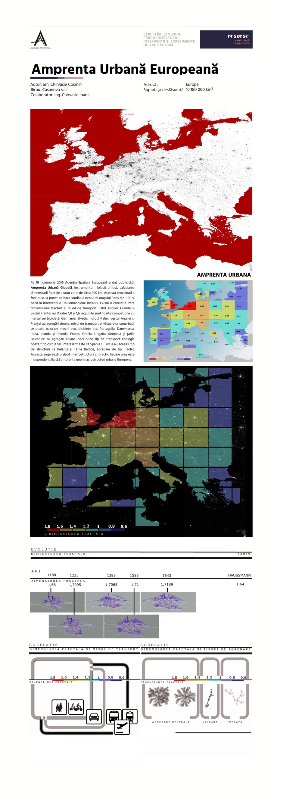
In 18 November 2016, European Space Agency (ESA) reveals Global Urban Footprint. (GUF) map.
The instrument used to compile the map was to calculate the fractal dimension on parts of ESA- GUF map (400 km range).
This procedure is based on a study of Paris evolution, between 1180 and Hassmannian interventions. Is a big correlation between fractal dimension and the nature of transportation mix.
East England, Belgium and Holland has fractal dimension between 1,8 and 1,6 , this suggests that the regions are very compatible with bike transportation.
Germany, Switzerland, north Italy, west England and west France has simple aggregations, so the future conurbations can use mix transportation based on ecological cars, bikes, etc.
Portugal, Denmark, Italy, Ireland and Poland, France, Greece, Hungary, Romania and Balkan countries have linear aggregations so any ecological transportation can equally be used.
Interesting is that Spain and Turkey has the same structure with Belarus and Baltic countries, dust aggregations. This suggests that exist a very low macro structure and the towns are practically independent.
European urban footprint macro structure exists.
- Shrinking Cities in Romania
- Industria Bumbacului » Industrii creative
- Tei Community Center
- Orthodox Refectory in the village of Movila
- European urban footprint
- Active house
- Experiential Beer Garden
- New MNIR
- Bonsai Story
- MEDS Bucharest - City of Contrasts
- (IN)VISIBLE MANIFESTATION OF EMOTION
- M House
- Hostel for Hope, Mwanza - Housing for improved access to cancer treatment for women
- Church in Copenhagen
- Sacred Space in Senegal (2nd place in the International Architecture Competition Kaira Looro, headed by Kengo Kuma)
- Trailer for Research and Activation (RCA)
- Weavers Tower - Cluj-Napoc
- De Wallen Hostel Amsterdam
- City Gate
- Divan Garden
- The Aqueduct and the Canvas
- Suburban residence in Lipia
- Răspiua – playground for all children
- Science City
- Block of flats assembly
- Formal-Informal Book support kit
- New MNIR
- Magi*K
